CONFIDENTIAL
UF-26004
The Lago de Coté UFO Photograph
- Incident
- 1971-09-04
- Location
- Lago de Coté, Arenal region, Costa Rica
- Coords
- 10.5833, -84.9833
Brief
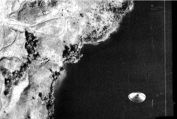
On the fourth of September 1971 an official Costa Rican government aerial-mapping aircraft automatically photographed a disc-shaped opaque object over Lago de Coté, though no one aboard saw anything. A peer-reviewed analysis by Richard F. Haines and Jacques F. Vallée found no evidence of double exposure or fabrication but could not identify the object, which remains contested.
Filed 2026-06-20 · Last updated 20 June 2026
Briefing
At approximately 08:25 (EDT) on the fourth of September 1971, a Costa Rican
government aircraft mapping Lago de Coté for terrain and hydroelectric study
work in the Arenal region automatically photographed an unidentified, opaque
aerial object over the lake while flying at about 10,000 feet [1]. The flight
was a routine aerial-mapping survey; the automatic survey camera exposed frames
at fixed intervals, and the object appears on only one frame, set against the
uniformly dark water [1][2]. No member of the crew reported seeing anything
unusual at the time [4].
Sequence of events
- The survey was undertaken in connection with terrain and hydroelectric study
work in the Arenal region. The crew comprised four people — an
aerial-photography specialist, a geographer, a topographer and the pilot —
none of whom reported seeing anything unusual [4].
- The camera was a Wild RMK 15/23 aerial mapping camera loaded with ASA 80 film
(Kodak air-safety film type 3665), producing a large negative of around ten
inches [2][3].
- At approximately 08:25 (EDT), flying at about 10,000 feet, the automatic
camera exposed the frame showing the disc-shaped object
over the lake [1].
- The object is reported to appear on frame number 300 of the survey run, set
against the uniformly dark water; it appears on only that single frame [1][2][3].
Documentary record
The principal source is the peer-reviewed paper “Photo Analysis of an Aerial
Disc Over Costa Rica” by Dr Richard F. Haines, a former NASA research
scientist, and Dr Jacques F. Vallée, published in the Journal of Scientific
Exploration, Vol. 3, No. 2 (1989), pp. 113–131, with a follow-up (“New
Evidence”) in Vol. 4, No. 1 (1990) [1]. Analysing second-generation black-and-white
negative and positive transparencies, the authors concluded that “an
unidentified, opaque, aerial object was captured on film at a maximum distance
of 10,000 feet. There are no visible means of lift or propulsion and no surface
markings other than dark regions that appear to be nonrandom… There is no
indication that the image is the product of a double exposure or a deliberate
fabrication” [1][2]. They noted that the object casts no visible shadow on the
lake surface, consistent with it being at or near the water surface, and raised
a fuzzy region on one side as a possible partial submersion or edge effect [2].
From the geometry the analysts derived a maximum possible diameter of roughly
683 feet, an upper bound assuming maximum distance [4].
The original negatives are held in Costa Rica’s National Archive, reported to be
catalogued under signatura NP-002544 and to contain five negatives and three
positives from the survey run, including the frame showing the object [3]. The
photograph is held on Wikimedia Commons as File:Cote_ufo.jpg, with rights
attributed to the Instituto Geográfico Nacional de Costa Rica under an
attribution-only licence — reusable with attribution, not public domain [5].
Open questions
- The primary analysis does not establish what the object is — only that it
is opaque, real to the film, and not an obvious fake [1].
- The exact distance, and therefore the true size, is unresolved; 10,000 feet
is a maximum, so the object could be far smaller and closer [1][4].
- No witness saw the object, so there is no firsthand sighting testimony to
corroborate the film [1][4].
- Whether the original first-generation negative has ever been examined under
glancing-light illumination — to rule out a physical film or optics artefact —
is not resolved in the available sources; Haines and Vallée themselves
recommended such an inspection [2].
- A caveat within the analysts’ own work flagged that the image “is more likely
to be an artifact such as a pressure mark than a photographic image of a
physical object” [2]. Later commentators have proposed alternatives: the
Rocky Mountain Paranormal Research Society (2013) argued for an internal lens
reflection arising from a specific combination of camera system, plane angle
and sun position; a “chipped glass” hypothesis (2014) proposes a stone-chip
on the camera glass producing a bullseye-like reflection; and a “boat wake”
explanation, attributed to commentator Michael Ian Black, attributes the
bright areas to sunlight on waves [2][3].
Status
This file is CONFIDENTIAL — admitted to the archive on the strength of an
official government survey photograph and a peer-reviewed analysis that found no
evidence of fabrication [1][5]. That analysis is explicit that the object is
unidentified, and the same authors recorded a caveat that the image may instead
be a camera artefact; this file therefore records a documented, unexplained
photograph, not a confirmed craft [1][2]. The image is widely described as a
“Daylight Disc” in the Hynek classification — a metallic or whitish object seen
by day — and local farmers were said to have previously reported strange objects
moving on or just below the lake surface, though neither claim is independently
verified here [4]. Crew names commonly cited in secondary accounts could not be
confirmed from a primary source in this pass and are omitted. Updates pending any
glancing-light re-examination of the original negative.
References
- Haines, R. F. & Vallée, J. F. (1989). “Photo Analysis of an Aerial Disc Over Costa Rica,” Journal of Scientific Exploration, Vol. 3, No. 2, pp. 113–131 (follow-up Vol. 4, No. 1, 1990). Hosted by NICAP.
- Gross, Patrick. “UFOs at close sight: the Lago de Cote photograph, 1971”. ufologie.net.
- Metabunk. “1971 Lake Cote / Lago de Cote UFO Aerial Photo”.
- Think AboutIt Docs. “1971: Lago de Cote Photograph”.
- File:Cote ufo.jpg. Wikimedia Commons / Instituto Geográfico Nacional de Costa Rica.
Frequently asked
- What is the Lago de Coté photograph?
- It is a single frame taken by an official Costa Rican government aerial-mapping aircraft on the fourth of September 1971, which automatically photographed an unidentified, opaque, disc-shaped object over Lago de Coté while flying at about 10,000 feet. No one aboard the aircraft reported seeing the object at the time.
- Was the Lago de Coté photograph proven to be fake?
- No. The peer-reviewed analysis by Dr Richard F. Haines and Dr Jacques F. Vallée, published in the Journal of Scientific Exploration in 1989, found no indication that the image was the product of a double exposure or a deliberate fabrication. They could not, however, identify what the object is, and a caveat within their own work flagged that it might instead be an artefact such as a pressure mark.
- How big was the object in the Lago de Coté photograph?
- The true size is unresolved. From the geometry, the analysts derived a maximum possible diameter of roughly 683 feet, but that figure assumes the maximum distance of 10,000 feet; the object could be far smaller and closer, so its actual size cannot be fixed.
- Where is the original Lago de Coté photograph held?
- The original negatives are held in Costa Rica's National Archive, reported to be catalogued under signatura NP-002544 with five negatives and three positives from the survey run. The image is also held on Wikimedia Commons, with rights attributed to the Instituto Geográfico Nacional de Costa Rica under an attribution-only licence.